
Rivers
-
A large constantly flowing collection of water moving towards a body of water.
-
The area a river flows in, with banks on each side.
-
a line showing the river from its source to its mouth. It shows how the river changes over its course.
-
shows you a cross-section of a channel or valley of a river. This is used to show the characteristics of a river or its valley at a certain point.
-
The place where a river starts, normally from higher ground.
-
The place where a river flows into a body of water, typically the ocean.
-
the section at the beginning of the river, nearest the source. This area is typically in upland higher altitude areas. Think hills and mountains.
-
The section of a river that flows through gently sloping land. The middle course come after the upper course.
-
towards the end of a river. It flows into another body of water. This could be the sea, an ocean, a loch or another river. The land around the river is is normally flat.
-
the process through which the river bed and bank are worn away.
-
the process through which the river drops its load. This happens when the river's speed decreases due to a loss of energy or a reduction in discharge.
-
The movement of sediment by the moving water of a river.
-
The scraping and scouring of the river bed and banks.
-
When sediment collide into each other, this gradually makes rocks smaller, smoother and rounder.
-
When the river sediment, bed and banks chemically react with the water, gradually dissolving material.
-
the force of fast-flowing water hits the bed and banks and forces water and air into cracks in the bedrock. The repeated changes in air pressure cause the river bed to weaken.
-
When large pieces of sediment, such as boulders, rocks and pebbles are rolled along the river bed.
-
when small sediment such as, pebbles and silt bounce along the river bed.
-
when fine pieces of sediment such as, sand and clay float within the water.
-
when dissolved minerals are carried by the water. this transportation cannot be seen.
-
The land area that is drained by a river and its tributaries.
-
the dividing line between two river systems and their drainage basins.
-
a stream or river that joins into a larger river or stream.
-
a bend in a river channel, normally found in the middle and lower course of a river.
-
the point at which two rivers meet.
-
they are areas of depressed land that are normally created by flowing water or ice. They are typically “U’ or “V” shaped.
-
a sudden and often vertical drop in a river.
-
a narrow and steep area of cliff walls often found downstream of a waterfall.
-
a “U” shaped body of water formed when a meander is cut off from a rivers flow.
-
a section of river where the current is very fast and turbulent.
-
the outside bend of a meander that is experiencing erosion and undercutting.
-
when erosion wears away part of the river bank leaving an overhang.
-
an embankment alongside a river, these can be natural or man-made.
-
a slope of deposited sediment normally found on the inside bend of a meander.
-
where a river enters the ocean. These areas are effected by tides.
-
when a mouth of a river fills with sediment, distributing the river into smaller rivers as it enters the ocean.
-
when sections of hills jut out into the course of the river causing the river to have to flow around them.
-
a valley with steep sloping sides in the shape of a “V”.
-
an area of flat land around a river. This area is typically found in the lower course of a river and will somtimes become covered in flood water from the river.
-
the process that changes water from a liquid to a gas (water vapor). Water moving from the Earth’s surface into the atmosphere.
-
when plants take in water and release it back into the atmosphere as water vapor.
-
Water being released from clouds in the form of rain, sleet, snow or hail.
-
the unconfined flow of water across the Earth’s surface.
-
water that can be found beneath the Earth’s surface.
-
a body of water that is surrounded by land, they are most likely to be freshwater.
-
a small moving channel of water. streams are much smaller than rivers.
-
an enormous body of saltwater. oceans cover around 70% of the Earth’s surface.
-
when water moves horizontally through the ground towards river channels.
-
when water filters through the soil and rocks of the Earth’s surface.
-
the term used to measure the amount of water moving past a given point.
-
when water moves down a plant stem or tree trunk towards the ground.
-
plants and trees covering an area of land.
-
a place where water that is moving underground finds an opening in the surface and emerges.
-
a place where water gathers and stays still for some time. Common examples are lakes, ponds and the ocean.
-
the process of water entering the surface of the Earth.
-
when water overflows its usual location and soaks land that is normally dry.
-
a substance is permeable if it allows water to pass through it.
-
a substance is impermeable if it does not allow water to pass through it.
-
when empty spaces in a material are filled with water.
-
an area made up of a large quantity of buildings. Cities are classified as urban areas.
Start of content
What is a river?
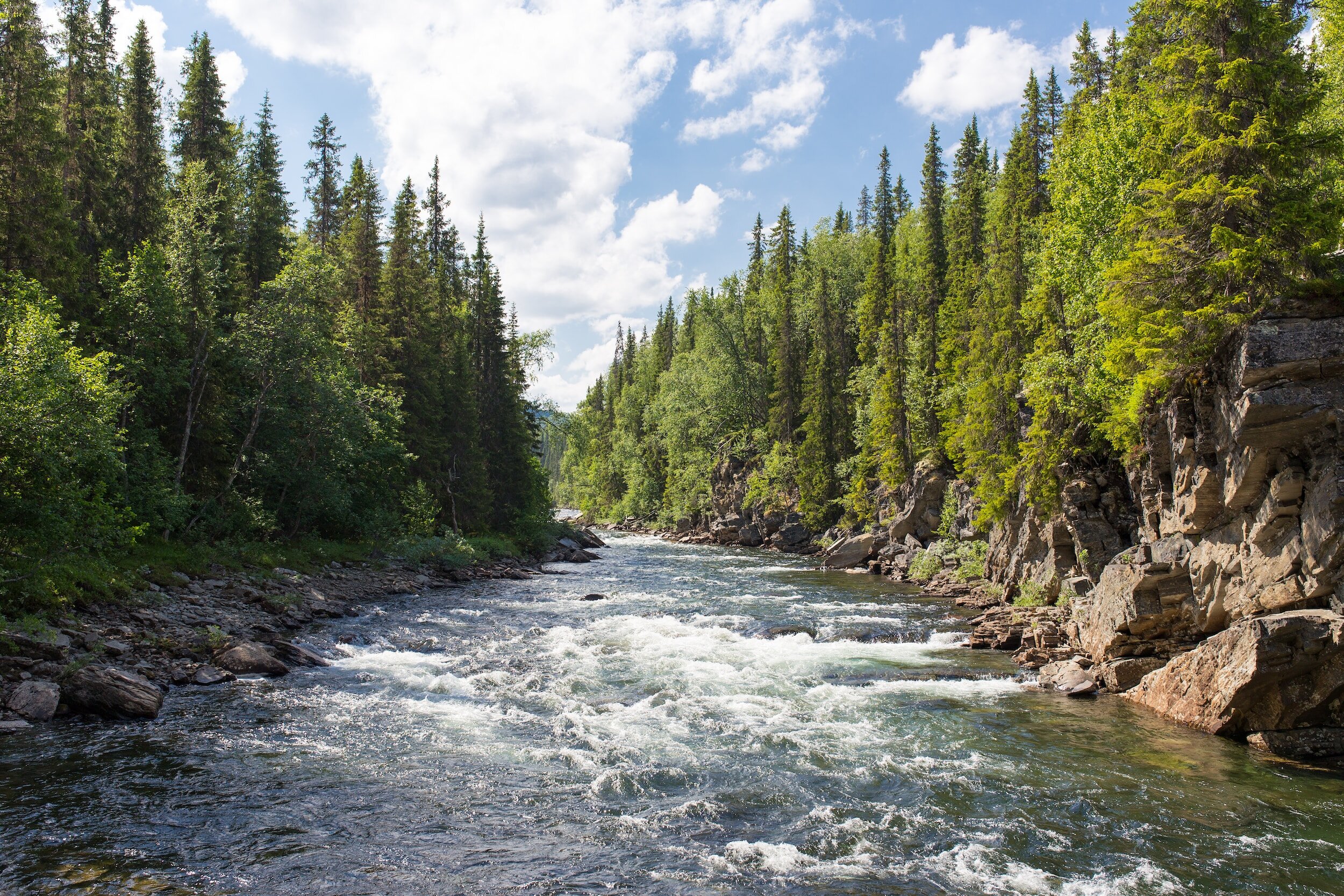
A river is a body of water that flows downhill, moved by the force of gravity. A river can be wide and deep, or shallow enough for a person to wade across. A flowing body of water that is smaller than a river is known as a stream. Some rivers flow all year-round, while others only flow during certain seasons or when there has been a lot of rain.
Long profile of a river
The water cycle
Transportation
Traction

Deposition
Deposition is when moving water no longer has sufficient energy to carry sediment, therefore the sediment is dropped. Sediment is normally deposited in similar areas, this can cause new sections of land to be created. Some common areas along a typical river are:
The inside bend of river
The mouth of a river
in areas that experience seasonal flow
The long profile of a river shows how a river and the land surrounding changes with distance from the source through three main sections.
Upper Course: The river here is shallow, straight and narrow. The valley is steep and often hilly.
Middle Course: The river here is deeper, bendier and wider. The valley is more gently sloping.
Lower Course: The river here is at its deepest, bendiest and widest. The valley is also very flat.
Cross profile of a typical river
A cross profile is is a cross section of a river. There are three main cross profiles we need to understand for rivers; The upper, middle and lower course cross profiles. Cross profiles show us the river channel and the surrounding area.

Upper course cross profile
A typical upper course cross profile will show the following characteristics:
Steep valley sides
Often “U” or “V” shaped valley profile
Relatively shallow river depth
Relatively narrow river channel


Drainage Basin
A drainage basin is the area of land surrounding a river that is drained by the river and its tributaries.
Some of the key features of a drainage basin are:
Source - this is where a river starts
Mouth - this is where a river ends and enters another body of water.
Watershed - this is the edge of the drainage basin, water inside the watershed will drain through. the basin water outside the line will drain into another drainage basin.
Confluence - this is where two rivers meet.
Tributary - this is the name given to a smaller river that joins a larger river.
Erosion

Abrasion
Abrasion is when rocks and sediment scrape and scour the river bed and banks. This makes the rocks smoother and damages the river sides.

Middle course cross profile
A typical middle course cross profile will show the following characteristics:
More gentlely sloping valley sides
A deeper river depth
A wider river channel

Attrition
Attrition is when rocks collide due to the force of water carrying them. When they hit each other they make each other smaller and smoother.

Saltation
Lower course cross profile
A typical lower course cross profile will show the following characteristics:
Mainly flat land surrounding the river, these are called flood plains.
The deepest river depth
The widest river channel
The water cycle is the continuous movement of water around Earth. It is made up of stores and transfers.
Stores - this is when water is kept stationary for a period of time. Some examples are the ocean, lakes and ice caps.
Transfers - this is when water is moving between stores. transfers are processes such as evaporation, condensation, precipitation and infiltration.
The water on Earth is sometimes referred to as the hydrosphere.


Hydraulic action
Hydraulic action is when the force of water causes cracks in the river bed and banks to expand by putting pressure on air trapped in the cracks.

Suspension

Solution
Solution is when rocks and minerals react to the chemical composition of the water causing part of them to dissolve.
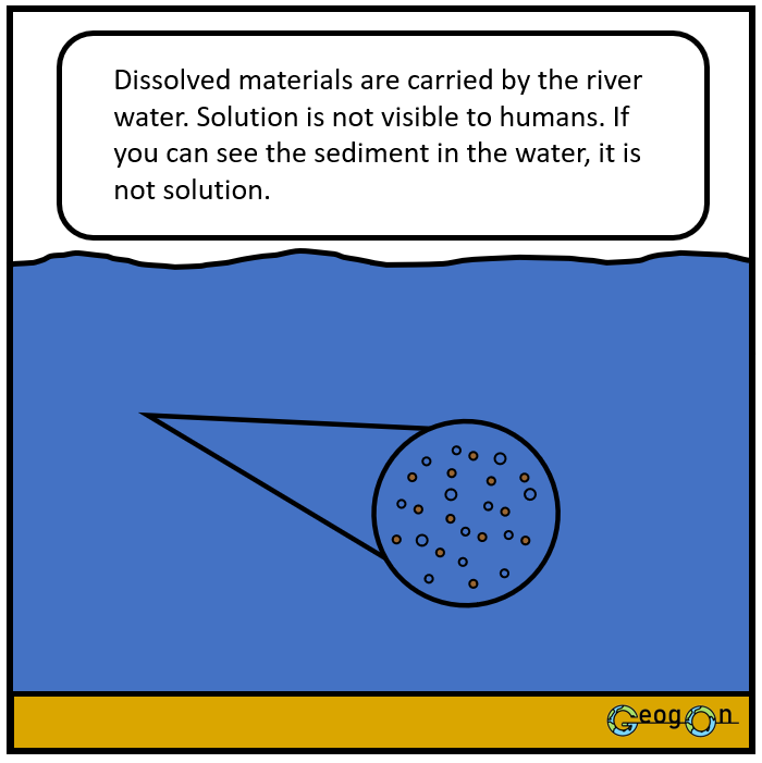
Solution

Upper Course

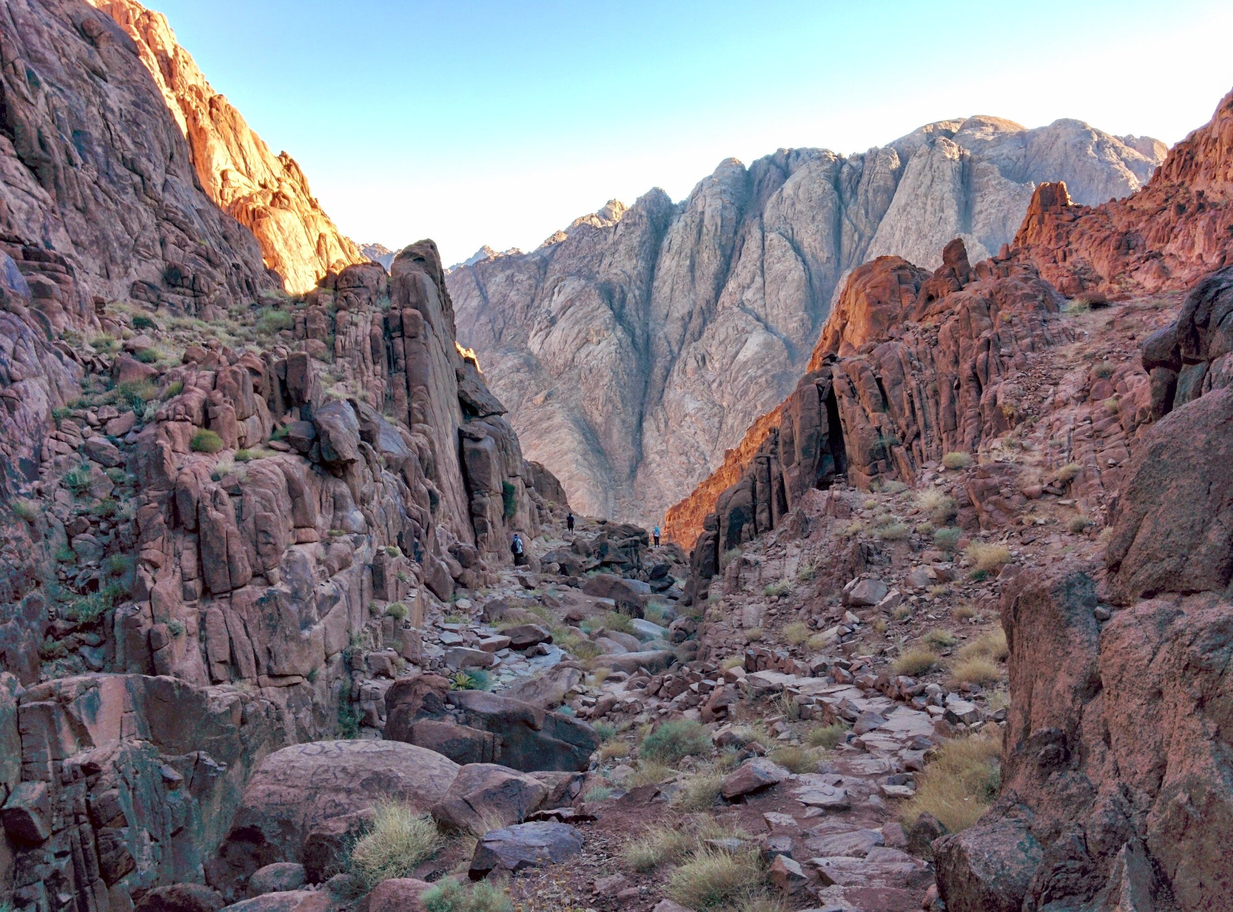
The upper course of a river typically has features such as; V-shaped valleys, interlocking spurs, waterfalls, rapids and gorges.
The typical characteristics of the upper course of a river are as follows:
Steep
Mountainous
Narrow river channel
Shallow river depth
Large bedload (sediment)
Angular bedload
Vertical erosion
Features of the Upper Course
V-shaped valley

V-shaped valleys are formed when the valley sides of rivers in the upper course are weakened by weathering and erosion. Because they are weakened they eventually collapse, this leaves behind steep sloping valley sides that when seen as a cross profile form a “V” shape.

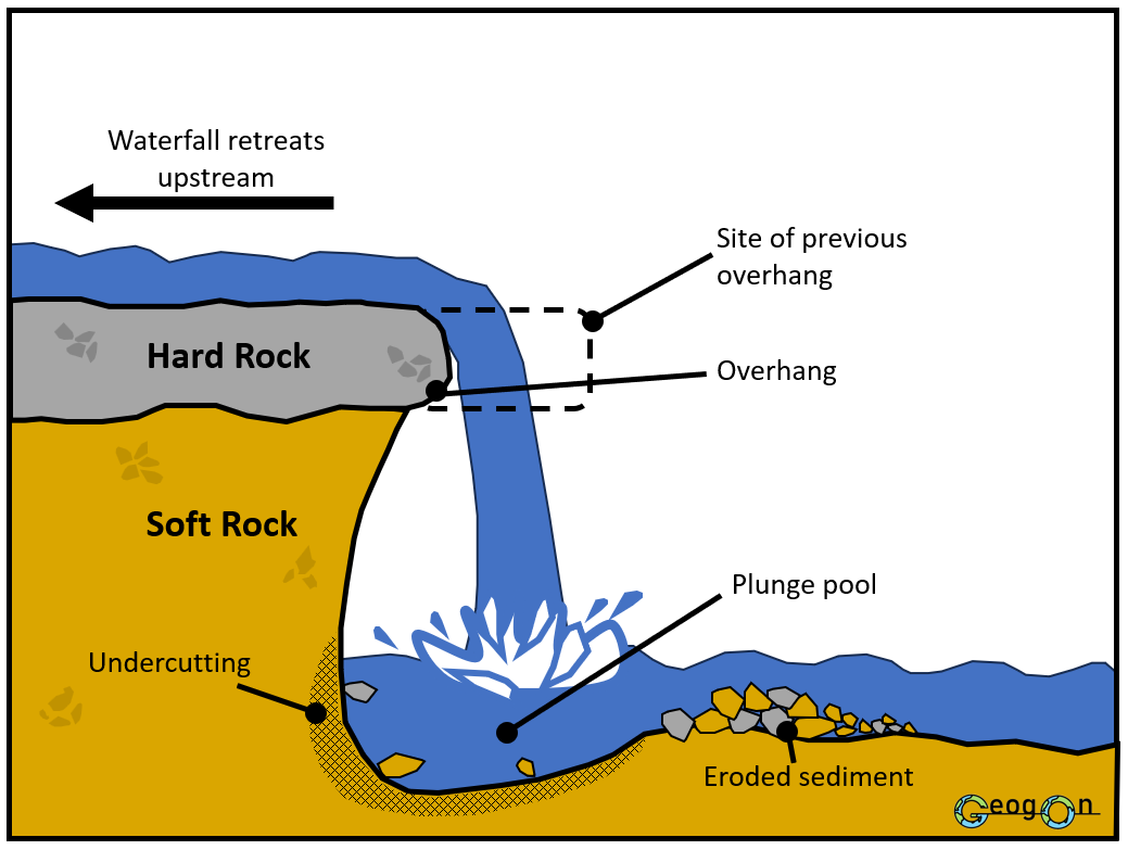
Waterfalls
Interlocking spurs
Interlocking spurs are a feature of the upper course of a typical river. They are found in hilly and mountainous regions.
Interlocking spurs are formed when a river is forced to bend around sections of hard (resistant) rock. As the river will always take the path of least resistance, this means that over time the river erodes vertically around these sections of rock creating interlocking hills. Sometimes people compare the hills to the teeth of a zip.
Interlocking spurs make it difficult to see the course of the river as the hills block your view of the river.
Waterfalls form in the upper course of rivers. There are 4 main stages in the formation of a typical waterfall. They are:
The river flows over bands of hard and soft rock. The softer rock is eroded quicker than the more resistant hard rock.
The river begins to erode vertically through the soft rock and starts to undercut the hard rock. This creates a plunge pool at the base of the waterfall and creates an overhang from the hard rock.
Over time erosion (abrasion and hydraulic action) continues to undercut the hard rock making the overhang bigger. Eventually, the overhang can no longer support its own weight and gravity causes it to collapse. This causes the waterfall to retreat upstream.
These steps repeat over and over again. As the waterfall continuously retreats upstream, a gorge is created in the area downstream of the waterfall.
Middle Course

The middle typically has features such as meander and oxbow lakes.
The typical characteristics of a river in the middle course are:
Less steep gradient
some rolling hills
wider river channel
deeper river depth
average size bedload (sediment)
more smooth bedload
Some vertical erosion but more lateral erosion
Features of the Middle Course
Stage formation of Meanders and Oxbow Lakes

Meanders and oxbow lakes are formed through a series of stages.
Firstly, a river in the middle course starts to experience more lateral erosion, this side to side erosion causes difference in flow across the width of the river. This variation in flow means that one side of a river will be flowing quicker than the other, the section of the river with the quicker flow will experience more erosion and the section with a slower flow will experience more deposition. The fastest flow alternates from bank to bank along the course of the river, this then starts to create curves known as meanders.
Secondly, the outside bends of the river are eroded further and the inside bends are built up through deposited material. This combination of processes causes the river course to migrate in the direction of the eroding bank. As the river migrates and the meanders become more curvy the river can sometimes erode towards itself creating a meander neck (this is shown in the second image where the two curves are moving towards each other).
Next, during a period of heavy flow such as a flood a river will break through this neck and create a straighter channel again. The remaining section of meander that is left is cut off from the main channel due to deposition. This section is known as an oxbow lake. Over time oxbow lakes can dry up and leave behind meander scars, these are the outline of where the channel used to be and are normally bow like in shape.
Cross section of a meander
A cross section of a meander shows that the inside bank of a meander is shallower and therefore experiences more friction which in turn leads to a slower flow and more deposition. This deposition causes the inside banks of meander to build up, creating features such as slip off slopes, which are beach like build ups of sediment that slop gently into the river.
Alternatively, on the outside bank of a meander there is normally a deeper channel that is experiencing less friction and therefore has a faster flow. This faster flow causes more erosion on the outside bank and causes the meander to expand in the direction of the erosion. In this process features such as river cliffs are created, these are steep sometimes overhanging undercut sections of the river bank.

Lower Course

The lower course typically has features such as; flood plains, levees, meanders, ox-bow lakes and deltas.
The typical characteristics of the lower course are:
Almost flat gradient
some rolling hills
widest river channel
deepest river depth
smallest size bedload (sediment)
smoothest bedload
only lateral erosion
Levees
Natural levees are formed in the lower course of most rivers through a process known as levee formation. When a river flows, it carries sediment, such as sand, silt, and clay, along with it. When the river floods onto the surrounding area ( its floodplain), the velocity of the water decreases, causing the sediment to settle. Over time, this sediment accumulates along the river banks, creating raised areas known as natural levees. These levees act as barriers, preventing the river from overflowing its banks during periods of high water flow or flooding. The repeated deposition of sediment during flood events further strengthens and widens the levees, enhancing their ability to contain the river within its channel. Typically larger sediment will settle closer to the river and smaller sediment will settle further away


Deltas
When a river reaches its mouth, the velocity of the river decreases significantly. As a result, the river loses its energy and begins to deposit the sediment it has been carrying. Flocculation occurs when fine sediment particles clump together, forming larger particles that settle more easily. These larger particles are then deposited at the river mouth, creating a landform known as a delta. The deposition of sediment continues over time, building up the delta and causing the river to split into multiple channels called distributaries. These distributaries carry the river's water and sediment to different areas, further contributing to the growth and expansion of the delta. Often a fractal like pattern is created.
Flooding
River flooding occurs when a river overflows its banks and spills onto the surrounding land. When the amount of water entering the river exceeds its capacity to hold it, the excess water spreads out onto nearby areas, causing flooding. River flooding can be destructive, as it can damage homes, infrastructure, and anything in the surrounding areas. It can also pose risks to human safety, as fast-moving floodwaters can be dangerous to navigate.
Causes of river flooding

Heavy rain:
Heavy rain is a direct and obvious cause of river flooding. When there is an intense and prolonged period of rainfall, the amount of water entering the river system can exceed its capacity, causing the river to overflow and flood its surrounding areas.

Saturated ground:
Saturated ground refers to soil that is already filled with water. When the ground is saturated, it cannot absorb additional rainfall, resulting in increased runoff. This excess water flows into rivers, raising their water levels and potentially causing flooding.
Impermeable rock:
Impermeable rock refers to rock formations that do not allow water to pass through easily. When a river flows through an area with impermeable rock, the water cannot seep into the ground, leading to increased runoff. This can contribute to higher water levels in the river, increasing the risk of flooding.

Built-up areas:
Built-up areas, such as cities or urbanized regions, can cause river flooding due to the increased amount of impermeable surfaces like roads, buildings, and parking lots. These surfaces prevent rainwater from infiltrating into the ground, leading to higher runoff volumes. As a result, rivers in built-up areas can experience faster and more significant increases in water levels during heavy rainfall, increasing the risk of flooding.

Steep ground:
Steep ground or slopes can contribute to river flooding by accelerating the flow of water. When heavy rain occurs on steep terrain, the water runs off quickly, increasing the volume and speed of water entering the river. This sudden influx of water can overwhelm the river's capacity, leading to flooding downstream.

Deforestation:
Deforestation can contribute to river flooding by disrupting the natural balance of ecosystems. Trees and vegetation play a crucial role in absorbing rainfall and regulating water flow. When forests are cleared, there is less vegetation to intercept and slow down rainfall, leading to increased runoff. This can result in higher river levels and an elevated risk of flooding downstream.
Flood management

Dams:
Dams are structures built across rivers to control the flow of water and prevent flooding downstream. They work by storing excess water during periods of heavy rainfall or snowmelt and releasing it gradually when the river flow decreases. This helps regulate the water levels and reduces the risk of flooding.
One advantage of dams is that they provide a reliable source of water for various purposes, such as irrigation and hydroelectric power generation. However, a disadvantage is that the construction of dams can lead to the displacement of communities and the alteration of natural ecosystems.

Embankments:
Embankments, also known as levees or flood walls, are raised barriers constructed along the banks of rivers to contain floodwaters within the river channel. They work by preventing water from spilling over onto surrounding areas. Embankments are typically made of soil, concrete, or a combination of both.
An advantage of embankments is that they provide immediate protection against flooding and can be built relatively quickly. However, a disadvantage is that they can create a false sense of security, as they may not be able to withstand extremely high floodwaters or unexpected breaches.

Warning Systems:
Warning systems are designed to provide timely alerts and information about potential or ongoing floods. These systems use various technologies, such as sensors, gauges, and weather forecasting, to monitor river levels and predict flood events. They can issue warnings through sirens, text messages, or mobile applications, allowing people to take necessary precautions and evacuate if needed.
An advantage of warning systems is that they help improve preparedness and response to floods, potentially reducing the loss of life and property. However, a disadvantage is that the effectiveness of warning systems relies on infrastructure, communication networks, and public awareness, which may be lacking in some areas.

Flood Shelters:
Flood shelters are designated safe locations where people can seek refuge during a flood event. These shelters are often built on higher ground or in sturdy structures that can withstand floodwaters. They provide temporary accommodation, food, and basic amenities for those displaced by flooding.
An advantage of flood shelters is that they offer a safe haven for people during emergencies and can help save lives. However, a disadvantage is that the capacity of these shelters may be limited, making it challenging to accommodate a large number of people during widespread flooding.

Emergency Help and Aid:
During and after a flood, emergency help and aid are crucial in providing immediate assistance to affected individuals and communities. This can include search and rescue operations, medical support, food and water supplies, temporary shelters, and financial assistance for recovery.
The advantage of emergency help and aid is that it addresses the immediate needs of those affected by flooding, helping them cope with the aftermath and rebuild their lives. However, a disadvantage is that the availability and accessibility of emergency help and aid can be challenging, especially in remote or disaster-prone areas. Coordination and logistics may also pose challenges in delivering aid effectively.
Bangladesh Case Study
Country: Bangladesh
Capital City: Dhaka
Population: Approximately 166 million (as of 2021)
Land Area: 147,570 square kilometers
Introduction:
Bangladesh is a country located in South Asia, known for its vulnerability to river flooding due to its unique geographical features. Situated in the delta region of the Ganges-Brahmaputra-Meghna river system, Bangladesh experiences frequent and severe flooding events. This case study will explore the causes, impacts, human responses, and management strategies related to river flooding in Bangladesh.
Causes of Flooding:
1. Heavy Monsoon Rainfall: Bangladesh receives heavy rainfall during the monsoon season, which leads to increased water levels in rivers and subsequent flooding.
2. Himalayan Snowmelt: The melting of snow in the Himalayas contributes to the flow of water into the rivers of Bangladesh, causing increased water levels and potential flooding.
3. Deforestation and Land Use Changes: Uncontrolled deforestation and improper land use practices, such as urbanization and agriculture, can disrupt natural drainage systems and exacerbate flooding.
4. Climate Change: Rising sea levels and increased frequency of extreme weather events, attributed to climate change, pose a significant threat to Bangladesh, leading to more severe and frequent flooding.
Impacts of flooding
Short-term impacts:
1. Loss of Lives and Displacement: Flooding often results in the loss of lives and the displacement of communities, leading to humanitarian crises.
2. Damage to Infrastructure: Floodwaters can damage roads, bridges, buildings, and other critical infrastructure, disrupting transportation and communication networks.
3. Destruction of Crops and Livestock: Floods can destroy agricultural fields and livestock, leading to food shortages and economic losses.
4. Spread of Waterborne Diseases: Contaminated floodwaters can lead to the outbreak of waterborne diseases, such as cholera and dysentery, posing health risks to the affected population.
Long-term impacts:
1. Economic Losses: Frequent flooding hampers economic development by damaging industries, disrupting trade, and causing long-term financial losses.
2. Environmental Degradation: Flooding can lead to soil erosion, salinization, and loss of biodiversity, negatively impacting the environment and ecosystems.
3. Social Disruption: Flooding can disrupt education, healthcare, and other essential services, affecting the overall well-being and social fabric of communities.
4. Migration and Urbanization: Recurring floods can force people to migrate from rural areas to urban centers, leading to unplanned urbanization and increased pressure on urban infrastructure.
Human Responses to Flooding:
1. Early Warning Systems: The government and NGOs have implemented early warning systems to alert communities about impending floods, allowing them to evacuate in a timely manner.
2. Flood Shelters and Relief Operations: Temporary shelters are set up to provide immediate assistance and relief to affected communities, including food, water, and medical aid.
3. Embankments and Flood Control Structures: Construction of embankments, levees, and flood control structures helps to mitigate the impact of flooding and protect vulnerable areas.
4. Community-Based Adaptation Measures: Local communities are encouraged to adopt measures such as raising homesteads, constructing elevated roads, and implementing flood-resistant agricultural practices to cope with flooding.
Management of River Flooding:
The management of river flooding in Bangladesh involves a combination of structural and non-structural measures:
1. Flood Forecasting and Monitoring: Continuous monitoring of river levels and weather conditions helps in predicting and preparing for potential flood events.
2. River Channel Dredging: Regular dredging of river channels helps maintain their capacity and improve water flow, reducing the risk of flooding.
3. Integrated Water Resource Management: Implementing comprehensive water resource management strategies, including basin-wide planning and coordination, helps in managing water resources effectively.
4. International Cooperation: Bangladesh collaborates with neighboring countries and international organizations to address transboundary river issues and develop joint flood management strategies.


Conclusion:
The case study on river flooding in Bangladesh highlights the country's susceptibility to flooding due to its deltaic geography and various human and physical factors. The impacts of flooding are significant, affecting lives, infrastructure, economy, and the environment. However, through a combination of human responses and effective flood management strategies, Bangladesh is striving to mitigate the risks associated with river flooding and build resilience in the face of future challenges.
Cumbria Case Study

Country: The United Kingdom
Population: 66.97 million
Capital and largest city: London
Area: 243,610 sq km (94,058 sq miles)
Major language: English
Major religion: Christianity
Life expectancy: 78.6 years
Introduction:
Cumbria is a region in northwest England that has experienced severe flooding in recent years, including major events in 2015 and 2021. These floods were caused by heavy rainfall from storms, leading to damage to homes, businesses, and infrastructure. This case study will look at the causes, impacts, and how people and authorities have responded to manage flooding in the area.


