
Coasts
-
The zone where land meets the sea.
-
Beaches are areas that are made up of eroded material. Most commonly sand and shingle.
-
A steep rock face found along coastlines.
-
The rising and falling of the sea due to the gravitational pull of the moon.
-
Waves are the movement of water. Most commonly caused by friction from the force of wind.
-
A wave that causes high levels of erosion. They have a stronger backwash than their swash.
-
The waves deposit more material on coasts than they erode. They build up beaches. They have a stronger swash than backwash.
-
The movement of a wave onto the coast.
-
The movement of a wave off the coast. The direction of backwash is determined by gravity.
-
The distance that wind can blow on the ocean surface.
-
The process of wearing away material.
-
When eroded material is dropped due to a lack of energy.
-
The process of erosion where the force of water (waves) causes air trapped in cracks to expand making the cracks larger.
-
The process of erosion where material being carried by water crash into each other making each other smaller.
-
The process of erosion where acids in sea water gradually dissolve material such as limestone.
-
The process of erosion where materials such as pebbles and sand are scraped against cliff faces creating friction.
-
The movement of sediment by water.
-
When dissolved minerals are moved within seawater. The minerals will not be visible.
-
When sediment bounces along the seafloor.
-
This is when light sediment remains floating in the water. Not touching the seafloor or the surface of the water.
-
This is when heavy sediment rolls along the seafloor, staying in contact with the ground.
-
An area of hard rock that sticks out into the sea. Created on coastlines that have alternating bands of hard and soft rock.
-
An area of coast that indents into the coastline. They are normally formed in areas of soft rock surrounded by an area of hard rock.
-
A line of weakness found in cliffs.
-
A hollow section of cliff. Normally created by a fault being made larger by hydraulic action.
-
When a cave erodes through a headland leaving a visible gap to the other side of the headland. They look like tunnels or doorways through cliffs.
-
When an arch collapses leaving behind a lone pillar of rock standing separate from the cliff.
-
When a stack eventually collapses leaving behind a smaller shorter section of rock.
-
The movement of material along a coast by waves which approach at an angle to the shore but recede directly away from it due to gravity. This normally occurs in a zig-zag pattern in the direction of the prevailing wind.
-
A continuation of a beach that juts out into the sea.
-
A spit that connects two headlands
-
When a spit connects to an island,
-
Wooden walls built at 90 degrees to the coast. They are designed to stop longshore drift.
-
Large boulders piled up on beaches to absorb wave energy.
-
Wooden barriers built parallel to the coast designed to absorb energy of waves while still allowing water to pass through.
-
Material is placed back on beaches to provide a natural defence against flooding and erosion.
-
Wire crates filled with rocks that are placed at the bottom of cliffs designed to absorb wave energy.
-
Large concrete walls built along coastlines. They are normally built with a recurved structure so that they reflect wave energy back out to sea.
Start of content
Why are coasts important?

Resource extraction
For taking precious resources from the ocean/seafloor such as oil or gas. This is important as these resources are used to produce energy and also provide industries and money for countries and their population.
Examples include:
North Sea where gas is extracted.
The Arabian Peninsula where oil is extracted.

Settlement
Population centers grew along coasts due to their easy access to industries such as fishing and international trade. Some of the worlds largest and most important cities are coastal for these reasons.
Examples include:
Shanghai, Hong Kong, Sydney, Tokyo, London and New York.

Industry
Coastal regions are ideal locations for large production and extraction industries as they normally have large open flat land and also provide a method of transporting their goods by boats. Also, fishing industries require easy access to the ocean so coastal areas make the most sense.
Examples include:
Shanghai Port, Netherlands and Liverpool docks.

Wildlife & Habitats
Coastal areas contain unique and often protected habitats such as coral reefs, salt marshes, mangroves and sand dunes. These areas are important as they provide very specific conditions that suit endangered animals and plants.
Examples include:
Great barrier reef, South Florida and southern Japan.

Tourism and recreation
Coasts are attractive locations and are normally appreciated for their natural beauty, this makes them ideal tourist destinations and great outdoor recreations areas. Tourism is important as it brings money to countries and businesses which helps with economic development.
Examples include:
Maldives, Thailand Phuket, Philippines, Bali and Cornwall.

Transport
Coasts are great for transporting people and goods by boats. Coastal cities are normally based around rivers where they meet the ocean so this also allows for transport of goods inland as well as to other countries.
Examples include:
Shanghai, New Orleans and London
How do waves form?
Waves are the motion of water. They can form in several different ways. The most common way that waves are formed is through frictional force between the wind and the ocean surface. Energy is transferred from the wind to the ocean surface which then creates waves.

What are tides?
What makes waves stronger?
Waves size and strength are determined by the follow factors:
The strength of the wind. The stronger the wind the stronger the waves.
The speed of the wind. The faster the wind the stronger the waves.
How long the wind has been blowing for. The longer the time the stronger the waves.
The size of the fetch. The longer the fetch the stronger and bigger the waves.
What is a fetch?

The length of ocean that wind can blow over creating waves. Normally the larger the fetch the stronger and larger the waves that are produced.
A will potentially produce the largest waves as it is the longest fetch.
B will potentially produce smaller waves than A.
C will most likely produce the smallest waves because it is the shortest fetch.

Tides are the varying heights of the ocean in coastal regions. High tide is the maximum height that the sea level will normally reach. Low tide is the lowest point that the sea level will normally reach.
High tides are 12 hours and 25 minutes apart. this means that the difference between a high tide and low tide is approximatley 6 hours and 12 minutes.
What causes tides?
Tides are caused by the gravitational pull of the Moon. Even though the Moon is much smaller than Earth it still has a significant effect on our planet.
The gravitational pull of the Moon actually causes Earths major bodies of water to bulge at the sections closest to and furthest from the Moon. These bulges are what create hightide. As water is pulled away from other areas between these bulges this reduces the water level creating low tide.
Wave Types

Coastal Erosion

-
![Comparison of rocks at the bottom of a body of water, showing minimal erosion and mineral dissolution today versus hundreds of years ago, when slightly acidic water dissolved minerals from the rocks.]()
Solution
Water dissolves soluble minerals and materials from rocks changing their structure, shape and size over a long period of time.
-
![Comparison of sediment size and distribution on a body of water bed hundreds of years ago and today, showing larger sediments in the past and smaller ones today.]()
Attrition
Rocks, pebbles and other materials are knocked into each other by the movement of water. As the rocks collide they gradually wear each other down becoming smaller, smoother and rounder.
-
![Comparison of a cliff underwater; hundreds of years ago, rocks are visible at the cliff base and a rock is being moved by water; today, the rocks are still at the base and no rocks are being moved.]()
Abrasion
The waves throw sand, rocks and other material at cliff faces. They scrape and scourer the cliff gradually wearing it away like sandpaper.
-
![Comparison of a cliff erosion process over hundreds of years and today. On the left, water exerts force causing cracks in the cliff over time. On the right, a person falls off the cliff, illustrating modern erosion effects.]()
Hydraulic Action
Waves and the force of water force air into cracks in cliff faces. The air is then trapped in these cracks. The force of water compresses the air in the cracks causing the cracks to expand over time.


Coastal Transportation

Traction


Suspension
Saltation


Longshore drift is a coastal process of transporting sediment.
The prevailing wind blows the swash onto the shoreline at the same angle as the prevailing wind. This swash brings sediment with it. The wave is then pulled off the shoreline as backwash. Gravity pulls the backwash off the shoreline at a right angle to the coast, along with the sediment it is carrying. The prevailing wind then blows the sediment and back onto the beach at the same angle again. This process repeats over and over again. The sediment is moved in the direction of the prevailing wind in a zig-zag motion along the coastline. This process is called longshore drift (LSD).
Formation of a spit
Coastal Deposition
Deposition is when material and sediment being carried by currents and waves are dropped in a new location. Deposition occurs due to a decrease in the energy of the waves and currents. If there is a drop in energy then less material can be carried.
As show in the diagram the higher the energy the larger size sediment can be carried. The lower the energy the smaller the size of sediment can be carried.
Headlands and Bays
Headlands and bays are formed when a coastline is made up of alternating bands of hard and soft rock. This type of coastline is called a discordant coast. As the coast is exposed to erosion over many years it is worn away and pushed back into the mainland. The softer sections of the coast are eroded quicker, this is where bays form. Bays are sections of land that are indented into the coast. The areas of hard rock that erode slower are left sticking out into the sea, these areas are called headlands.

Cave, Arch, Stack and Stump
Solution
Longshore Drift

When a headland experiences continued erosion it can create coastal features such as caves, arches, stacks and stumps. All of these features follow a step by step pattern, one turns into the next.
Firstly a fault (1) or a line of weakness is exposed and eroded on the headland, mainly by hydraulic action. Over time, the fault grows in size and becomes a cave (2).
Caves (2) eventually break through the headland, due to continued erosion by hydraulic action and abrasion. This creates an arch (3).
An arch (3) is a door like structure that passes from one side of the headland to the other. The base of the arch continues to be eroded and the top of the arch is worn away by weathering. Eventually, the arch can no longer support its roof and it collapses (4) leaving behind a lone column of rock called a stack (5).
Stacks (5) are very exposed to the forces of the ocean and are eroded on all sides. Finally, when a stack can no longer support its own weight it collapses leaving behind a short broken rock pile. This pile is called a stump (6).

A spit is a feature of deposition, they are formed through movement and deposition of material at coast lines. The direction of the prevailing wind determines the direction of swash onto the coastline, gravity pulls the backwash of the wave off the coastline at a right angle to the coast. This process is called longshore drift. Longshore drift moves material along the coast line in the same direction of the prevailing wind in a zig-zag motion. Through this process, material is constantly moved along the coast line. When the coast line reaches a headland, changes direction or there is a river estuary the process of longshore drift continues off the land and into the water. If the water is shallow enough, gradually over time the sediment builds up creating a new beach stretching out into the water. This beach is normally a long thin strip that is attached to the coast where there was a change in the coast. A change in currents or wind direction often causes the spit to have a hooked shape. If a spit is formed at a river estuary then material can build up behind the spit and this can cause marshlands and salt marshes to appear.
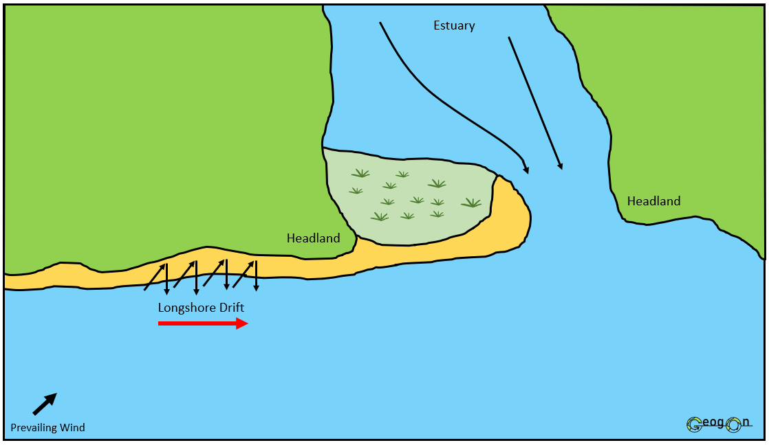
The formation of a spit

The points needed for a 6 mark answer on the formation of a spit.
Spits, Bars and Tombolos

Spit

Coastal Management
Bar

There are two methods of coastal management.
These are hard engineering and soft engineering.
Hard engineering: This method of coastal protection uses man made structures that are often imposing on the natural environment.
Soft engineering: This method of coastal protection uses natural resources and the environment to help protect and manage coastal regions. This method is normally more environmentally sustainable than hard engineering.
Methods of Coastal Management


Gabions
Hard Engineering.
Gabions are wire cages that are filled with rocks, these are normally used to offer protection to cliff lined coastal regions. They are designed to absorb and reduce wave energy and slow down erosion. They are seen as a less expensive option. Some people think they are ugly.

Groynes
Hard Engineering.
Often made from wood, groynes are wall like structures that are built at a right angle to the beach. Groynes are designed to stop the movement of sediment by longshore drift. Groynes cause beaches to build up and form a natural barrier that protects the area behind it from erosion.
Sea Wall
Hard Engineering.
Walls are built along coastal region that require high levels of protection, these areas are normally the most populated or are important due to services they provide. The walls that are built are normally curved and designed to reflect wave energy back out to sea.


Revetments
Hard Engineering.
Slanted structures quite often made form wood that are placed parallel to the coast. They are not too expensive but do require maintenance. They absorb large amount of wave energy but still allow water to pass through them. They have been known to increase the strength of backwash.


Rock Armour
Hard Engineering.
Rock Armour is when large boulders are placed along areas of coast that require protection. Normally, these are used along cliffs but are also used to help protect sea walls that are ageing and require expensive maintenance. The boulders are normally not from the local area and are brought from areas of hard rock.

Tombolo
Beach Nourishment
Soft Engineering.
Natural material such as sand and shingle is added to the beach to help the beach naturally reduce the impacts of erosion on the area to the back of the beach. The beach material is normally taken from the bottom of the ocean near the coast. This can damage and disrupt local marine life.
The Holderness Coast
The Holderness Coast is eroding rapidly due to a combination of soft geology (mainly boulder clay cliffs), strong wave action, and longshore drift, which moves sand and shingle along the coast. The softer boulder clay is easily worn away by the sea, leading to high rates of erosion, with some areas eroding by several meters each year. This has significant effects, including the loss of valuable land, homes, and infrastructure, as well as the destruction of habitats for local wildlife. In response, various coastal management strategies have been put in place, such as sea walls, groynes, and rock armour at locations like Mappleton and Withernsea to reduce erosion and protect settlements. However, at places like Spurn Point, managed retreat is being used, allowing natural processes to shape the coastline while focusing on protecting key areas.
