
Plate Tectonics
-
Hot fluid or semifluid material below or within the earth's crust from which lava is formed.
-
Made liquid by heat; melted.
-
Rock that in its molten form (as magma) erupts from volcanoes; lava is what magma is called when it reaches the surface.
-
An opening in the earth's crust through which molten lava, ash, and gases are ejected.
-
A volcano with long, gentle slopes, built primarily by lava flows.
-
Volcanic cones are among the simplest volcanic formations. They are built by ejecting material from a volcanic vent, piling up around the vent in the shape of a cone with a central crater.
-
Known as Stratovolcano, it is a tall, conical volcano built up by many layers (strata) of hardened lava, tephra, pumice, and volcanic ash. The lava that flows from stratovolcanoes typically cools and hardens before spreading far due to high viscosity.
-
Is an enormous volcano that is an order of magnitude larger than ordinary volcanoes. A supervolcano occurs when a huge magma chamber in the Earth's crust erupts after being under great pressure, causing a large caldera to form as the land over the magma chamber collapses.
-
Powdery material thrown out by a volcano.
-
A bowl-shaped depression at the mouth of a volcano or geyser.
-
The specific pattern of the movement of a fluid due to differences in temperature and density in the fluid.
-
The surface of the earth is composed of many large plates which slowly move around the planet, meeting and diverging, creating a variety of earthquakes, volcanoes, and mountains at their margins.
-
The outer layer of the Earth.
-
The layer of the earth between the crust and the core.
-
The core is a layer rich in iron and nickel found in the interior of the Earth. It is composed of two sub-layers: the inner core and outer core. The core is about 7,000 kilometres in diameter.
-
Occur where two plates slide apart from each other. Mid-ocean ridges (e.g. Mid-Atlantic Ridge) and active zones of rifting (such as Africa's Great Rift Valley) are both examples of divergent boundaries.
-
Occur where two plates slide towards each other commonly forming a subduction zone. One plate will be continental and the other oceanic.
-
Is the process by which one tectonic plate moves under another tectonic plate, sinking into the Earth's mantle, as the plates converge. This normally creates high levels of friction and commonly can cause earthquakes.
-
The oceanic trenches are large scale long but narrow depressions of the sea floor. They are also the deepest parts of the ocean floor. These are normally formed around subduction zones.
-
This is the space between two plates that are moving alongside each other. either in the same direction at different speeds or in different directions. The most well known conservative plate boundary is the San Andreas Fault
-
When two continental plates collide, neither can sink and so the land buckles upwards to form fold mountains.
-
Fold Mountains are a type of mountain range that is formed when two continental plates collide. The colliding crust is compressed and pushed upwards (uplifted), forming mountains.
-
A sudden and violent shaking of the ground, sometimes causing great destruction, as a result of movements within the earth's crust or volcanic action.
-
the point on the earth's surface vertically above the focus of an earthquake.
-
the place inside Earth's crust where an earthquake originates or started from.
-
A long high sea wave caused by an earthquake or other disturbance.
-
A numerical scale for expressing the magnitude of an earthquake on the basis of seismograph oscillations.
-
A twelve-point scale for expressing the local intensity of an earthquake.
-
The moment magnitude scale was designed to produce a more accurate accounting of the total energy released by an earthquake, and it calculates the earthquake’s magnitude more accurately than other measures—such as the Richter scale.
-
A wave in the earth produced by an earthquake.
-
A P wave is one of the two main types of elastic body waves, called seismic waves in seismology. P waves travel faster than other seismic waves and hence are the first signal from an earthquake to arrive at any affected location or at a seismograph.
-
An S wave, also called a secondary or shear wave, is a seismic body wave that shakes the ground back and forth perpendicular to the direction the wave is moving. These are normally the more destructive wave.
Start of Content
The Earth’s Structure

The Earth has a very distinct structure and can easily be divided into 4 layers. These layers are: the Crust, Mantle, Outer Core and Inner Core. These layers have their own characteristics and measurements. We cannot physically go to any of the internal layers of the Earth, no matter what the film industry leads you to believe. This makes understanding and studying the structure of the Earth very difficult. scientists map the interior by watching how seismic waves from earthquakes are bent, reflected, sped up, or delayed by the various layers.
Crust
The Crust is the outermost layer of our planet. It’s thickness ranges from 6km in some very deep sections of the oceans to 70 km in some of the worlds mountain ranges. The Crust is made of solid minerals and rocks, it is in no way a uniform layer and varies in density and temperature dependent on its location on our planet.
Mantle
The Mantle is the mostly-solid bulk of Earth's interior. The Mantle lies between Earth's dense, super-heated Core and its thin outer layer, the Crust. The Mantle is about 2,900 kilometers thick, and makes up 84% of Earth’s total volume. The temperature of the mantle varies, from 1000° Celsius near the crust, to 3700° Celsius near the Core. The viscosity of the Mantle varies greatly dependent on where it is, it is at its most liquid state near plate boundaries.
Outer Core
The outer core, about 2,200 kilometers thick, is mostly composed of liquid iron and nickel. The Outer Core is very hot, between 4,500° and 5,500° Celsius.
Inner Core
The inner core is a hot, dense ball of iron. It has a radius of about 1,220 kilometers. The temperature in the inner core is about 5,200° Celsius. The pressure is nearly 3.6 million atmospheres.
Convection Currents

Convection currents within the Mantle are the cause of many features and events on the Earth’s surface.
So what are they and how do they work? The diagram explains the process.
A: The mantle is a semi-solid mass that can move slowly. The bottom of the Mantle is much hotter than the top the disparity in heat causes the bottom of the Mantle to rise towards the Crust because hot material is less dense that cold material.
B: When the hotter material approaches the Crust it starts to cool again. As the material cools it starts to sink again towards the hotter Outer Core, where it will be heated again. This movement of the material in the Mantle creates what we know to be convection currents. A circular movement of material through rising and falling caused by heating and cooling.
C: Convection currents then create friction between the moving Mantle and the tectonic plate that make up the Crust of our planet. This friction causes the plates to move very slowly. Plates move at around the same speed your fingernails grow.
D: Where plates are pushes together one plate is normally forced under the other. This process is called subduction.
Tectonic Plates
The crust of the Earth is divided into immense slabs of rock. These slabs of rock are called tectonic plates. these plates are slowly moved around the planet by the convection currents underneath them in the mantle. The plates are given names so that we can identify them, the names are normally related to the countries, continents or oceans on their surface. The edges of the plates, where they meet other plates are the most common locations for tectonic activity such as earthquakes and volcanos.

Tectonic Plate Theory

The Jigsaw Theory
This theory is simple. Have you ever looked at a map of the world and thought “doesn’t the east coast of South America look like it fits the west coast of Africa?”
This is not a coincidence in fact it is one of the most common points made when supporting tectonic theory, countless scientist and explorers have pointed this out throughout history.
Alfred Wegener - Published this theory and other ideas and findings that supported this theory.
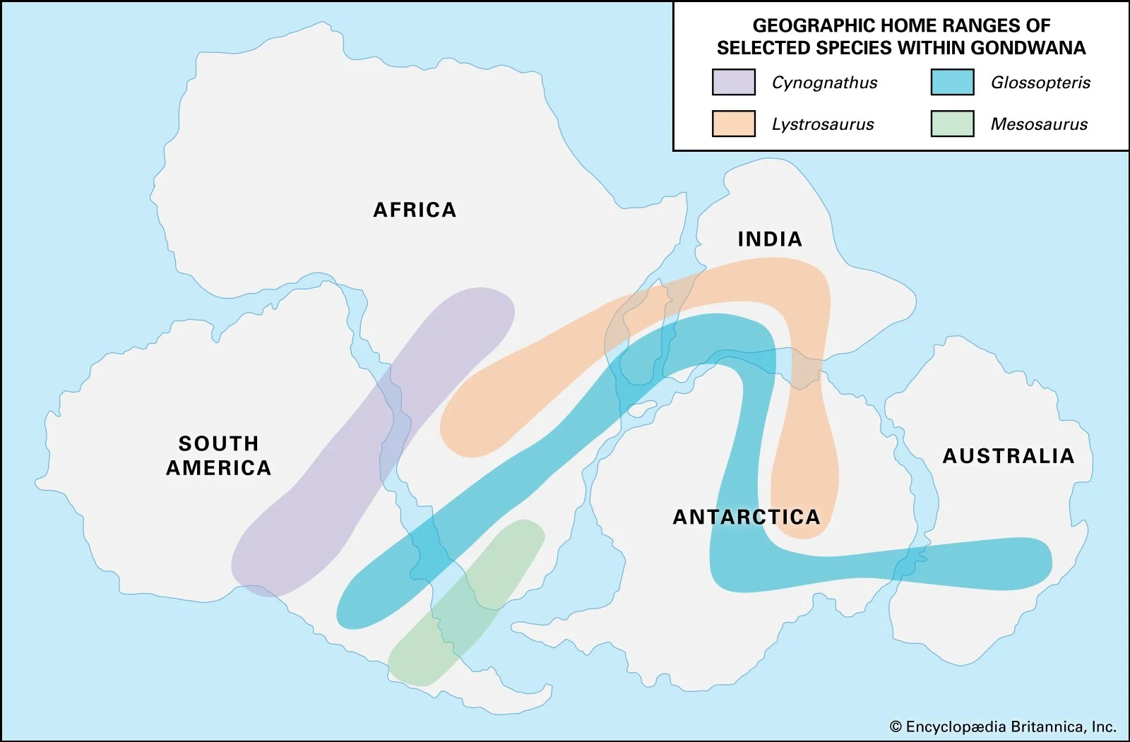
Fossil Records
Fossils of the same animals and plants have been found on different continents in rocks of similar geological ages, This would suggest that the land masses were once connected. The strong part of this evidence is that the fossils found are of animals that would have had no method of crossing such large bodies of salt water and the plants found are now in completely different climates that would not have supported their growth.

Sea Floor Spreading
The changes in rock as you move away from constructive plate boundaries actually gives us evidence to support tectonic theory.
Firstly, The age of the crust gets older as you move away from the Mid-Atlantic ridge, this was discovered in 1953.
Secondly, as magma cools is aligns to Earth's magnetic field. The Earths magnetic field switches switches from north to south every 300,000 years it last occurred 42,000 years ago. This means that the magnetic material in rocks changes its alignment in bands as you move away from the plate boundary.
The mid-Atlantic ridge is the main example used when discussing this theory.
Plate Boundaries
-
![Diagram of a volcano erupting with labels showing oceanic plate, subduction zone, mantle, and continental plate.]()
Destructive Boundary
At a destructive plate boundary two plates move towards one and other. One plate is then forced underneath the other. It is the lighter plate that is forced beneath the heavier plate. The point at which one plate is forced beneath the other is called the subduction zone. Volcanoes are common at destructive plates boundaries, this is due to the weaknesses that are created and the melting of one of the plates.
-
![Diagram of two tectonic plates, one blue and one brown, with arrows indicating their movements. Plate B is moving upward, while plate A is moving downward, showing divergent or tectonic boundary activity.]()
Conservative Boundary
At conservative plate boundaries plates slide past each other in opposite directions, or in the same direction but at different speeds. This movement creates large amounts of friction. Eventually, friction is overcome and the plates slip past in a sudden movement. This is often the cause of earthquakes.
-
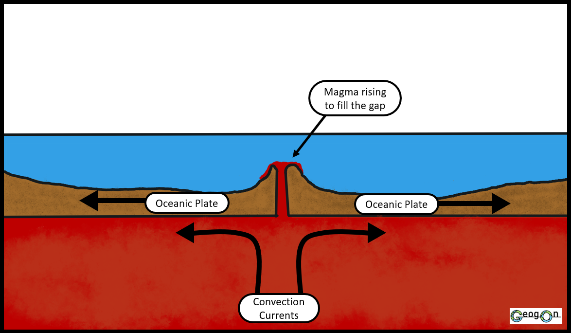
![Diagram showing oceanic plates diverging at a mid-ocean ridge with magma rising to fill the gap, creating new crust, and convection currents in the mantle causing the plates to move apart.]()
Constructive Boundary
At constructive plate boundaries, the plates are moving away from each other. As they move apart they create a new gap for rising magma to flow into. As the molten rock rises into this new gap it cools and solidifies often creating new crust. These plate boundaries are most common between two oceanic plates.
-
![Diagram showing the process of plate tectonics, with two continental plates colliding, causing the formation of fold mountains and a crack in the Earth's crust.]()
Collison Boundary
At collision plate boundaries two plates move towards each other, these plates are normally both continental. As the two plates collide over millions of years they crumble and break each other down. This collision causes sections of the crust to uplift and most commonly creates fold mountains.


Types of Volcano

Composite Cone
Composite cone volcanoes are normally found on destructive plate boundaries. Typically they erupt in a violent manner but do so less frequently that shield volcanoes. They normally have steep sides, this is due to the acidic lava which is very sticky and therefore does not travel far from the crater. Composite cones are often made up of alternating layers of lava and ash, this is due to the way in which they erupt.

Shield
Shield volcanoes are normally shorter and wider than composite cone volcanoes, they are normally found on constructive plate boundaries. Shield volcanoes are almost exclusively basalt volcanoes. Basalt produces a very fluid type of lava, this means that when the lava leaves the volcano it can actually travel a large distance before it solidifies. Shield volcanoes do not have explosive eruptions. Normally over 90% of the volcano is made from lava and not other volcanic material.
Location of Volcanoes
Volcanoes follow a simple locational pattern. You will notice when comparing the image of currently erupting volcanoes to the map of tectonic plates that most volcanoes are found near to or are on a plate boundary.
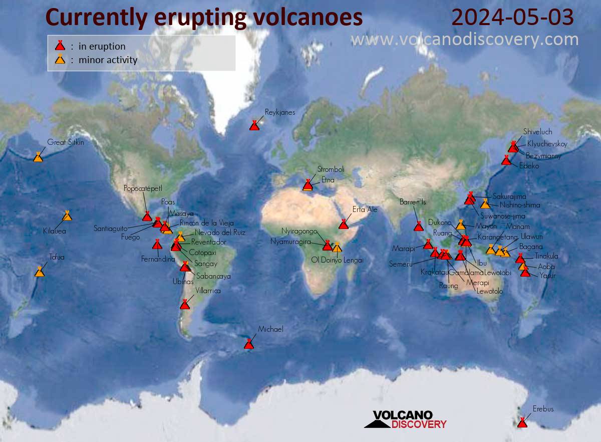
Visit: https://www.volcanodiscovery.com/volcanoes.html if you want to investigate current volcanic eruptions.

Earthquakes

An earthquake occurs when two blocks of the earth normally plates, suddenly slip past one another after overcoming an immense amount of friction. The surface where they slip is called a fault. The location below the earth’s surface where the earthquake starts is called the focus and the location directly above it on the surface of the earth is called the epicenter.
The majority of earthquakes happen around or on plate boundaries, conservative plate boundaries produce the most frequent earthquakes, a prime example of this would be the San Andreas Fault in California.
Earthquakes create seismic waves, these are vibrations and movements within the Earth’s crust caused by the release of energy of the tectonic slip/movement. If an Earthquake is strong enough sometimes these wave can be seen physically moving through the ground.
Earthquake Location
Earthquakes follow a simple locational pattern. You will notice when comparing the interactive map of recent earthquakes to the map of tectonic plates that most earthquakes happen near to or are on a plate boundaries. You can also turn on the plate boundaries layer on the map. Give it a go!
To see move, visit: https://www.volcanodiscovery.com/earthquakes/major.html

Measuring Earthquakes

Richter Scale - a numerical scale for expressing the magnitude of an earthquake on the basis of seismograph oscillations. The more destructive earthquakes typically have magnitudes between about 5.5 and 8.9; the scale is logarithmic and a difference of one represents an approximate thirtyfold difference in magnitude.
Moment magnitude - quantitative measure of an earthquake’s relative size, developed in the 1970s. Calculations of an earthquake’s size using the moment magnitude scale are tied to an earthquake’s seismic moment rather than to the amplitudes of seismic waves recorded by seismographs. The moment magnitude scale is the only scale capable of reliably measuring the magnitudes of the largest, most destructive earthquakes (that is, greater than magnitude 8).